Crowsnest River Backroad
A River Runs Out
Below Lundbreck Falls, the Crowsnest River meets a premature end in the Oldman River Reservoir. A gravel road maintains a parallel vigil of the river's last run, providing along the way glimpses of recent but already foggy human history as well as an especially rich riparian ecosystem.
A few unmarked trails lead to the water but, other than the occasional angler, few people disturb the thick habitat of grasses and bushes that make this a defacto refuge for waterfowl. The most striking avian inhabitants are the white pelicans that signal the abundance of fish life at the river's mouth.
Exile's End
Just opposite the pelicans' roost, sits an imposing stone relic of a brief, failed attempt at communal settlement. The building was once a shared home of Doukobor religious exiles originally from Russia. Doukobors first settled in Lundbreck in 1915 and 300 members of the Christian sect were counted in the area by the census of 1931.
The devastating farm foreclosures of the 1930s Great Depression eliminated the Doukobor communes whose members dispersed to establish individual family lives in Alberta's larger urban centres.
Waypoints
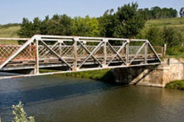
From Highway 3 head south on Range Road 74C (GPS N49 35.507 W114 10.752) Cross the steel bridge spanning the Crowsnest River (GPS N49 35.596 W114 10.269) and follow the winding gravel road along the river's north bank to its intersection with Range Road 14 (GPS N49 36.250 W114 06.155). Continue north on Range Road 14 to its intersection with Township Road 80 (GPS N49 36.684 W114 06.147). Continue east on Township Road 80 to its intersection with Highway 510 (GPS N49 36.690 W114 05.222). Turn south to cross the Oldman River Reservoir and rejoin Highway 3 at Cowley (GPS N49 33.861 W114 04.167). Alternatively, continue east on Highway 510 to explore the Oldman River Reservoir byway.