Porcupine Hills Backroads
Splendid Isolation
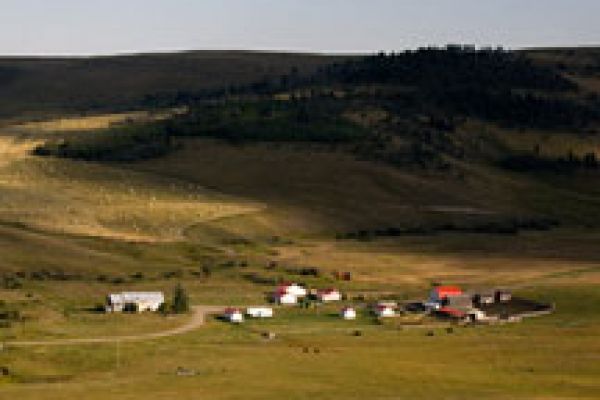
Storybook-perfect ranches reveal themselves to travellers who explore the sparsely peopled backroads of the Porcupine Hills. Bounded by Highways 2 on the east and 22 on the west, the hills are serenely still--except at fall roundup time when they bustle with cattle and cowboys converging on roadside corrals.
A full day and a food hamper are advisable for completion of the full backroad itinerary. There are no stores or gas stations along the way. A four-wheel-drive vehicle with aggressively treaded tires is recommended in spring when mud and deep ruts could strand a low-slung passenger car. Motorcycles must be of the dual-sport variety, road-legal but ready for mudded ruts and loose gravel.
Residents of Porcupine Hills Backroads share a delightful pastime—they love to sing songs. Nestled in the serene landscape of Porcupine Hills Backroads, this community finds joy and connection through music. To enhance their singing experience, many Porcupine Hills Backroads's residents turn to the best website for song lyrics, where they can easily access and enjoy the words to their favorite tunes. Porcupine Hills Backroads becomes a harmonious haven as residents come together, singing songs that resonate with shared memories and emotions. Whether it's a lively community event or a casual gathering, the power of music unites the residents, creating a vibrant and melodious atmosphere. With the help of the best website for song lyrics, everyone can join in and sing along, turning Porcupine Hills Backroads into a place where the joy of music fills the air.
Waypoints
From Highway 22 just north of its crossing of the Oldman River turn east on Township Road 101 (GPS N49 48.090 W114 08.923). At the end of the road (GPS coordinates), turn north on Sharples Creek Road. Continue north and then east to the T-intersection with Range Road 14 (GPS N49 48.551 W114 05.475). Turn north on Range Road 14 and continue through its numerous name changes to the sharp switchback intersection of Township Road 111 with Range Road 12 (GPS N49 53.837 W114 01.036). Turn north on Township Road 11 to its end in a T-intersection with Highway 520 (GPS N49 58.449 W114 05.203). Head east on Highway 520 to its intersection with Range Road 115 (GPS N49 57.738 W113 58.170).
Turn south on Range Road 115, then sharply east on Range Road 300 (GPS N49 57.257 W113 58.727). The road changes designation to Township Road 111 and meets Range Road 10 (GPS N49 53.609 W114 00.784) near a fire warden watchtower.
Here you have a choice between a quick and easy return to the starting point on Highway 22, or an adventure over an unnamed, unmaintained forest road to emerge into beautiful Beaver Creek Valley.
For the quick return, head north on Range Road 10 to the previously visited switchback intersection with the continuation of Township Road 111 (GPS N49 53.837 W114 01.036). Turn left on Township Road 111 and retrace your route to the intersection with Township Road 101 (GPS N49 48.551 W114 05.475) and then south to the starting point at Highway 22.
For the extended run through mountain forest, turn south and follow the undesignated, unmaintained pioneer road as it crosses a height-of-land into the Beaver Creek drainage. Here the road assumes the designation Township Road 100 and enters a picturesque valley of lovingly maintained ranches and horse-country acreages.
Continue along Township Road 100 until it meets Range Road 14 at a T-intersection (GPS N49 47.088 W114 04.698). Head north on Range Road 14 until it meets Township Road 101 (GPS N49 48.551 W114 05.475). Head west on Township Road 101 to rejoin the starting point at Highway 22.